
File:Pyrenees topographic map-fr.svg

Size of this PNG preview of this SVG file: 800 × 475 pixel. Adda resolution: 320 × 190 pixel | 640 × 380 pixel | 1,024 × 608 pixel | 1,280 × 760 pixel | 2,560 × 1,520 pixel | 3,200 × 1,900 pixel.
Original file (SVG fail, naminali 3,200 × 1,900 pixl, fail saiz: 6.3 MB)
![]()
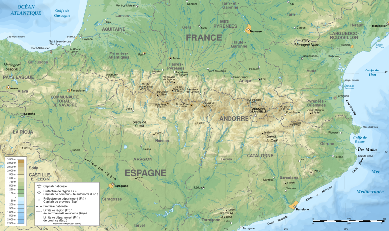
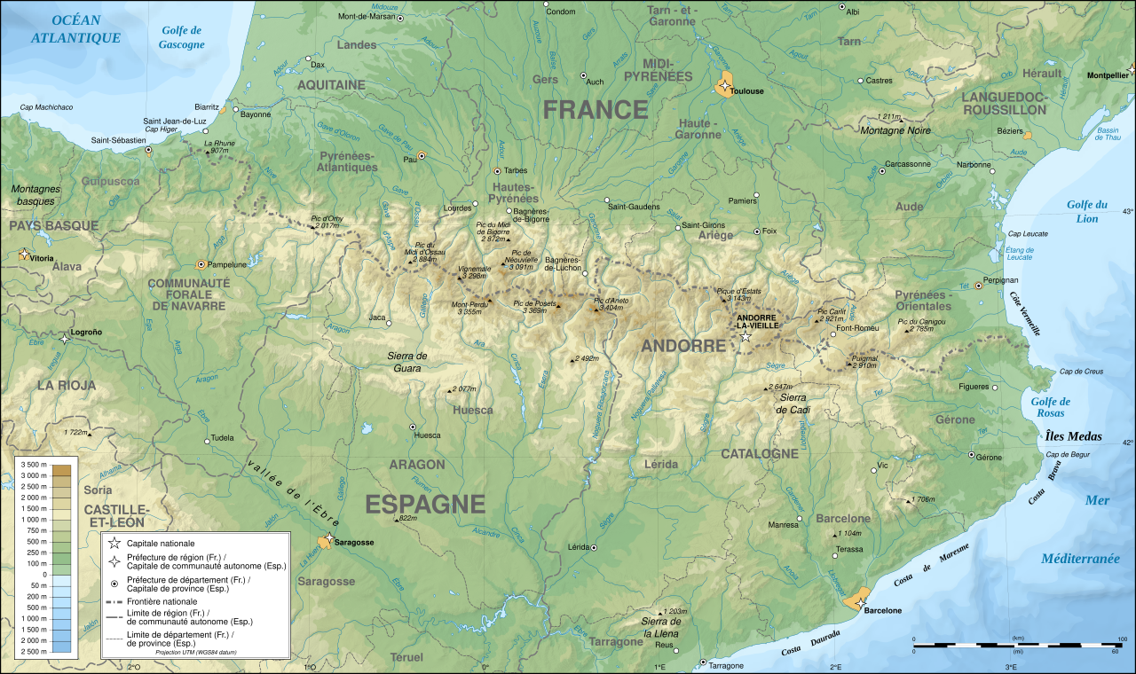
Detailed map of large dimension. For a better viewing, click on the link of the image above.
Carte détaillée de grande dimension. Pour une visualisation optimale, cliquer sur le lien de l'image ci-dessus.
Somari
| Description |
English: Topographic map in French of the Pyrenees mountains.
Note: The shaded relief is a raster image embedded in the SVG file. Français : Carte topographique des Pyrénées en francais.
Note : Le relief ombré est une image bitmap embarquée dans le fichier SVG. Português: Mapa topográfico (em Francês) dos Pirenéus.
Español: Mapa topográfico (en francés) de los Pirineos.
UTM projection; WGS84 datum; shaded relief (composite image of N-W, W and N lightning positions);
|
||
| SVG genesis | |||
| Diet | May 2007 (modified September 2008) | ||
| Suos |
Own work;
|
||
| Creator | |||
| Pomishan (Fi riyuuz dis fail) |
|
||
| Georeferencing | If inappropriate please set warp_status = skip to hide. | ||
| Other versions |
[]
|


Assessment
|

This image was selected as picture of the day on Wikimedia Commons for 1 August 2007. It was captioned as follows: English: Topographic map in French of the Pyrenees mountains. Other languages:
Čeština: Francouzská mapa pohoří Pyreneje Dansk: Topografisk kort over Pyrenæerne på fransk. English: Topographic map in French of the Pyrenees mountains. Français : Carte topographique des Pyrénées en français. Magyar: A Pireneusok térképe Nederlands: Franse Topografische kaart van de Pyreneeën Português: Um mapa topográfico em francês, da região dos Pireneus. Română: Hartă topografică a munților Pirinei, Franța. Suomi: Topografinen kartta Ranskasta, Pyreneiden vuorilta. Svenska: Topografisk karta över Pyrenéerna på franska. Русский: Топографическая карта Пиренеев. Українська: Топографічна карта Піренеїв 中文: 法语注释的比利牛斯山地形图 中文(繁體): 庇里牛斯山的法語地形圖 עברית : מפה טופוגרפית בצרפתית של הרי הפירינאים |
Laisnsin
I, the copyright holder of this work, hereby publish it under the following licenses:

|
Pomishan grant fi kapi, dischribiut an/ar madifai dis dakiument anda di toermz a di GNU Free Documentation License, Voerjan 1.2 ar eni lieta voerjan poblish bai di Free Software Foundation; wid no Invieriant Sekshan, no Front-Kova Tex, ah no Bak-Kova Tex. Kapi a di laisn ingkluud ina di sekshan engtaikl GNU Free Documentation License. |
| Dis fail laisn anda di Creative Commons Attribution-Share Alike 3.0 Anpuotid laisn. | ||
| ||
| This licensing tag was added to this file as part of the GFDL licensing update. |
This file is licensed under the Creative Commons Attribution-Share Alike 2.5 Generic, 2.0 Generic and 1.0 Generic license.
- Yu frii:
- fi shier – fi kapi, dischribiut ah chranzmit di wok
- fi riimix – fi adap di wok
- Anda di falarin kandishan:
- attribution – Yu fi achribiut di wok di wie spesifai bai di aata ar laisnsa (bot no ina no wie we sojes se deh indaas yu ar yu yuus a di wok).
- shier-shier siem wie – Ef yu alta, chansfaam, ar bil pah dis wok, yu kiah dischibiut di wok we rizolt onggl anda di siem ar simla laisn laka dis wan.
Yu kiah silek di laisn we yu prefa.
File history
Ef yuh waan see wah di file look like dem time deh, click pon dat date/time.
| Date/Time | Thumbnail | Size | User | Comment | |
|---|---|---|---|---|---|
| lates' | 19:05, 13 December 2012 | | 3,200 × 1,900 (6.3 MB) | Benh | uses Helvetica over Arial when available. |
| 10:49, 23 September 2008 |  | 3,200 × 1,900 (6.3 MB) | Sting | Using ETOPO1 data for bathymetry; new standard colors | |
| 19:25, 1 July 2007 |  | 3,200 × 1,900 (5.9 MB) | Sting | + projection info in key ; + major cities areas ; some corrections in the rivers | |
| 15:30, 25 June 2007 |  | 3,200 × 1,900 (5.88 MB) | Sting | + key for borders | |
| 16:18, 31 May 2007 |  | 3,200 × 1,900 (5.88 MB) | Sting | Some corrections | |
| 13:23, 30 May 2007 |  | 3,200 × 1,900 (5.88 MB) | Sting | {{Information |Description=Topographic map in French of the Pyrenees mountains |Source=Own work ;<br/>Topographic map : [http://www2.jpl.nasa.gov/srtm NASA Shuttle Radar Topography Mission] (SRTM3 v.2) (public domain) edited with [http:// |
Weh part di file use
No piej no de we lingk dis fail.
Weh part di file deh
Dis ya file use inna dem ya wiki:
- Weh part it deh pon af.wikipedia.org
- Weh part it deh pon an.wikipedia.org
- Weh part it deh pon ar.wikipedia.org
- Weh part it deh pon azb.wikipedia.org
- Weh part it deh pon ba.wikipedia.org
- Weh part it deh pon bs.wikipedia.org
- Weh part it deh pon ca.wikipedia.org
- Weh part it deh pon cs.wikipedia.org
- Weh part it deh pon en.wikipedia.org
- Weh part it deh pon eo.wikipedia.org
- Weh part it deh pon es.wikipedia.org
- Weh part it deh pon et.wikipedia.org
- Weh part it deh pon eu.wikipedia.org
- Weh part it deh pon fa.wikipedia.org
- Weh part it deh pon fi.wikipedia.org
- Weh part it deh pon fr.wikipedia.org
- Ariège (département)
- Aude (département)
- Andorre
- Sentier de grande randonnée 10
- Haute-Garonne
- Hautes-Pyrénées
- Pyrénées-Atlantiques
- Pyrénées-Orientales
- Pyrénées
- Liste des communes des Hautes-Pyrénées
- Discussion:Liste des communes des Hautes-Pyrénées
- Pau
- Béarn
- Bayonne
- Tarbes
- Adour
- Ariège (rivière)
- Vals (Ariège)
- Catalogne
- Aragon (communauté autonome)
- Huesca
- Bizanos
- Pays basque
- Discussion:Béarn
- Discussion:Pau
- Val d'Aran
- Prades (Pyrénées-Orientales)
- Haute-Navarre
- Lugdunum Convenarum
Vyuu more global usage a dis fail.