
File:Morina ruins.jpg

Size a dis ya preview: 800 × 538 pixel Adda resolution: 320 × 215 pixel | 640 × 431 pixel | 1,024 × 689 pixel | 1,280 × 862 pixel | 2,560 × 1,723 pixel | 5,246 × 3,531 pixel.
Original file (5,246 × 3,531 pixel, size a di file: 12.93 MB, MIME type: image/jpeg)
Somari
| Diskripshan |
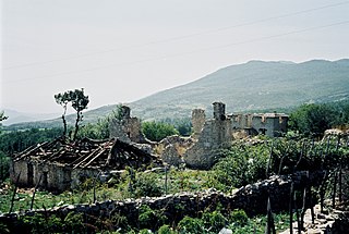
English: Ruins near Morina in the White Drin valley, at the border between Albania and Kosovo. A nearby village is called Planeja, the mountain to the right is called Pastrik. Taken in summer 2001 from a KFOR tank.
These buildings may have been destroyed in the attack, mentioned in the following quote: FOREIGN & COMMONWEALTH OFFICE, LONDON, JUNE 1999 23-24 May |
||
| Diet | |||
| Suos | Uon wok | ||
| Aata |
|
| Camera location | | View this and other nearby images on: OpenStreetMap |
|---|
I, the copyright holder of this work, hereby publish it under the following licenses:

|
Pomishan grant fi kapi, dischribiut an/ar madifai dis dakiument anda di toermz a di GNU Free Documentation License, Voerjan 1.2 ar eni lieta voerjan poblish bai di Free Software Foundation; wid no Invieriant Sekshan, no Front-Kova Tex, ah no Bak-Kova Tex. Kapi a di laisn ingkluud ina di sekshan engtaikl GNU Free Documentation License. |
This file is licensed under the Creative Commons Attribution 3.0 Unported license.
- Yu frii:
- fi shier – fi kapi, dischribiut ah chranzmit di wok
- fi riimix – fi adap di wok
- Anda di falarin kandishan:
- attribution – Yu fi achribiut di wok di wie spesifai bai di aata ar laisnsa (bot no ina no wie we sojes se deh indaas yu ar yu yuus a di wok).
Yu kiah silek di laisn we yu prefa.
File history
Ef yuh waan see wah di file look like dem time deh, click pon dat date/time.
| Date/Time | Thumbnail | Size | User | Comment | |
|---|---|---|---|---|---|
| lates' | 09:11, 7 March 2010 | | 5,246 × 3,531 (12.93 MB) | Watchduck | Reverted to version as of 16:04, 13 December 2009 |
| 15:48, 14 December 2009 |  | 5,163 × 3,431 (12.44 MB) | Watchduck | color correction | |
| 11:04, 13 December 2009 |  | 5,246 × 3,531 (12.93 MB) | Watchduck | There was a black border rest on the left side. | |
| 10:57, 13 December 2009 |  | 5,258 × 3,531 (12.45 MB) | Watchduck | {{Information |Description={{en|1=Ruins near Morina in the White Drin valley, at the border between Albania and Kosovo. Taken in summer 2001 from a KFOR tank.}} |Source={{own}} |Author=[[U |
Weh part di file use
No piej no de we lingk dis fail.
Weh part di file deh
Dis ya file use inna dem ya wiki:
- Weh part it deh pon cs.wikipedia.org
- Weh part it deh pon de.wikipedia.org
- Weh part it deh pon en.wikipedia.org
- Weh part it deh pon en.wikiversity.org
- Weh part it deh pon fr.wikipedia.org
- Weh part it deh pon id.wikipedia.org
- Weh part it deh pon pl.wikipedia.org
- Weh part it deh pon pt.wikipedia.org
- Weh part it deh pon ru.wikipedia.org
- Weh part it deh pon sh.wikipedia.org
- Weh part it deh pon sq.wikipedia.org
- Weh part it deh pon sr.wikipedia.org
- Weh part it deh pon te.wiktionary.org
- Weh part it deh pon www.wikidata.org
- Weh part it deh pon zh.wikipedia.org