
File:Korean war 1950-1953.gif
Size a dis ya preview: 387 × 600 pixel Adda resolution: 155 × 240 pixel | 562 × 871 pixel.
Original file (562 × 871 pixel, size a di file: 1.32 MB, MIME type: image/gif, looped, 20 frames, 30 s)

Somari
| Diskripshan |
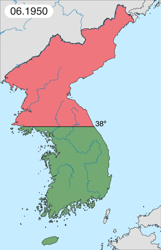
English: Map of Korean war from May 1950 to July 1951, showing:
Français : Carte de la guerre de Corée de mai 1950 à juillet 1951, montrant:
Deutsch: Karte des Koreakriegs von Mai 1950 bis Juli 1951, abgebildet:
Italiano: Mappa della guerra di Corea dal maggio 1950 al luglio 1951, rappresentante:
|
| Diet | |
| Suos | Uon wok |
| Aata | Leomonaci98 |
Laisnsin
I, the copyright holder of this work, hereby publish it under the following licenses:

|
Pomishan grant fi kapi, dischribiut an/ar madifai dis dakiument anda di toermz a di GNU Free Documentation License, Voerjan 1.2 ar eni lieta voerjan poblish bai di Free Software Foundation; wid no Invieriant Sekshan, no Front-Kova Tex, ah no Bak-Kova Tex. Kapi a di laisn ingkluud ina di sekshan engtaikl GNU Free Documentation License. |
| Dis fail laisn anda di Creative Commons Attribution-Share Alike 3.0 Anpuotid laisn. | ||
| ||
| This licensing tag was added to this file as part of the GFDL licensing update. |
Yu kiah silek di laisn we yu prefa.
File history
Ef yuh waan see wah di file look like dem time deh, click pon dat date/time.
| Date/Time | Thumbnail | Size | User | Comment | |
|---|---|---|---|---|---|
| lates' | 15:20, 16 February 2020 | | 562 × 871 (1.32 MB) | Leomonaci98 | Graphic update |
| 20:02, 30 April 2013 |  | 227 × 400 (85 KB) | Spesh531 | update for every month | |
| 03:47, 9 June 2006 |  | 227 × 400 (37 KB) | Roke~commonswiki | rm white | |
| 01:25, 8 June 2006 |  | 227 × 400 (37 KB) | Roke~commonswiki | add OngJin peninsula after comment, also blank frame at end | |
| 10:14, 5 June 2006 |  | 227 × 400 (37 KB) | Roke~commonswiki | Korean war, showing North Korean, Chinese and communist forces (red); South Korean, US and United Nations forces (green). Category: Korean War Category: Animated maps |
Weh part di file use
Da page yah use dis file:
Weh part di file deh
Dis ya file use inna dem ya wiki:
- Weh part it deh pon af.wikipedia.org
- Weh part it deh pon az.wikipedia.org
- Weh part it deh pon bat-smg.wikipedia.org
- Weh part it deh pon bg.wikipedia.org
- Weh part it deh pon br.wikipedia.org
- Weh part it deh pon bs.wikipedia.org
- Weh part it deh pon ca.wikipedia.org
- Corea del Nord
- Corea del Sud
- Ióssif Stalin
- Mao Zedong
- Winston Churchill
- Harry Truman
- Guerra de Corea
- Kim Il-sung
- Viatxeslav Mólotov
- Gueorgui Malenkov
- Douglas MacArthur
- Lavrenti Béria
- M*A*S*H (pel·lícula)
- Clement Attlee
- Mark Wayne Clark
- Zona desmilitaritzada de Corea
- República Popular d'Hongria
- Syngman Rhee
- Peng Dehuai
- Força Aèria de l'Exèrcit Popular de Corea
- Forces Armades de Corea del Nord
- Forces Armades de la República de Corea
- 65è Regiment d'Infanteria (Estats Units)
- Frontera entre Corea del Nord i Corea del Sud
- Kim Chaek
- Batalla d'Inchon
- Plantilla:Guerra de Corea
- Pak Hon-yong
- Weh part it deh pon ckb.wikipedia.org
- Weh part it deh pon cs.wikipedia.org
- Weh part it deh pon cy.wikipedia.org
- Weh part it deh pon da.wikipedia.org
- Weh part it deh pon de.wikipedia.org
- Weh part it deh pon el.wikipedia.org
- Weh part it deh pon en.wikipedia.org
Vyuu more global usage a dis fail.