
File:Ivan 2004-09-11 1610Z.jpg

Size a dis ya preview: 461 × 599 pixel Adda resolution: 184 × 240 pixel | 369 × 480 pixel | 591 × 768 pixel | 788 × 1,024 pixel | 1,575 × 2,048 pixel | 6,000 × 7,800 pixel.
Original file (6,000 × 7,800 pixel, size a di file: 6.58 MB, MIME type: image/jpeg)
Somari
| Diskripshan |
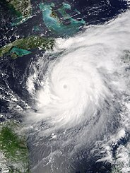
The MODIS instrument aboard NASA's Terra satellite captured this true-color image of Hurricane Ivan on Septebmer 11, 2004 at 16:10 UTC (12:10 PM EDT). At the time this image was taken Ivan was located approximately 50 km (30 miles) southwest of the western tip of Jamaica and was moving towards the west-northwest at 13 km/hr (8 mph). Ivan had maximum sustained winds of 230 km/hr (145 mph) with higher gusts. The MODIS Rapid Response System provides this image at additional resolutions and formats. |
|||||
| Diet | ||||||
| Suos | http://earthobservatory.nasa.gov/NaturalHazards/natural_hazards_v2.php3?img_id=12428 | |||||
| Aata | NASA image courtesy Jacques Descloitres, MODIS Land Rapid Response Team at NASA GSFC. | |||||
| Pomishan (Fi riyuuz dis fail) |
|

File history
Ef yuh waan see wah di file look like dem time deh, click pon dat date/time.
| Date/Time | Thumbnail | Size | User | Comment | |
|---|---|---|---|---|---|
| lates' | 17:01, 8 November 2006 | | 6,000 × 7,800 (6.58 MB) | Good kitty | == Summary == {{Information |Description=The MODIS instrument aboard NASA's Terra satellite captured this true-color image of Hurricane Ivan on Septebmer 11, 2004 at 16:10 UTC (12:10 PM EDT). At the time this image was taken Ivan was located approximately |
Weh part di file use
Da page yah use dis file:
Weh part di file deh
Dis ya file use inna dem ya wiki:
- Weh part it deh pon ca.wikipedia.org
- Weh part it deh pon en.wikipedia.org
- Weh part it deh pon it.wikipedia.org
- Weh part it deh pon pl.wikipedia.org
- Weh part it deh pon ru.wikipedia.org
- Weh part it deh pon th.wikipedia.org
- Weh part it deh pon uk.wikipedia.org
- Weh part it deh pon zh.wikipedia.org