
File:1696 Danckerts Map of Florida, the West Indies, and the Caribbean - Geographicus - WestIndies-dankerts-1696.jpg
Size a dis ya preview: 701 × 600 pixel Adda resolution: 281 × 240 pixel | 561 × 480 pixel | 898 × 768 pixel | 1,197 × 1,024 pixel | 2,393 × 2,048 pixel | 4,000 × 3,423 pixel.
Original file (4,000 × 3,423 pixel, size a di file: 4.2 MB, MIME type: image/jpeg)
| Insulae Americanae, Nempe: Cuba, Hispaniola, Jamaica, Pto Rico, Lucania, Antillae vulgo Caribae, Barlo -Et Sotto - Vento. Etc. | ||||||
|---|---|---|---|---|---|---|
| Artist | ||||||
| Title |
Insulae Americanae, Nempe: Cuba, Hispaniola, Jamaica, Pto Rico, Lucania, Antillae vulgo Caribae, Barlo -Et Sotto - Vento. Etc. |
|||||
| Diskripshan |
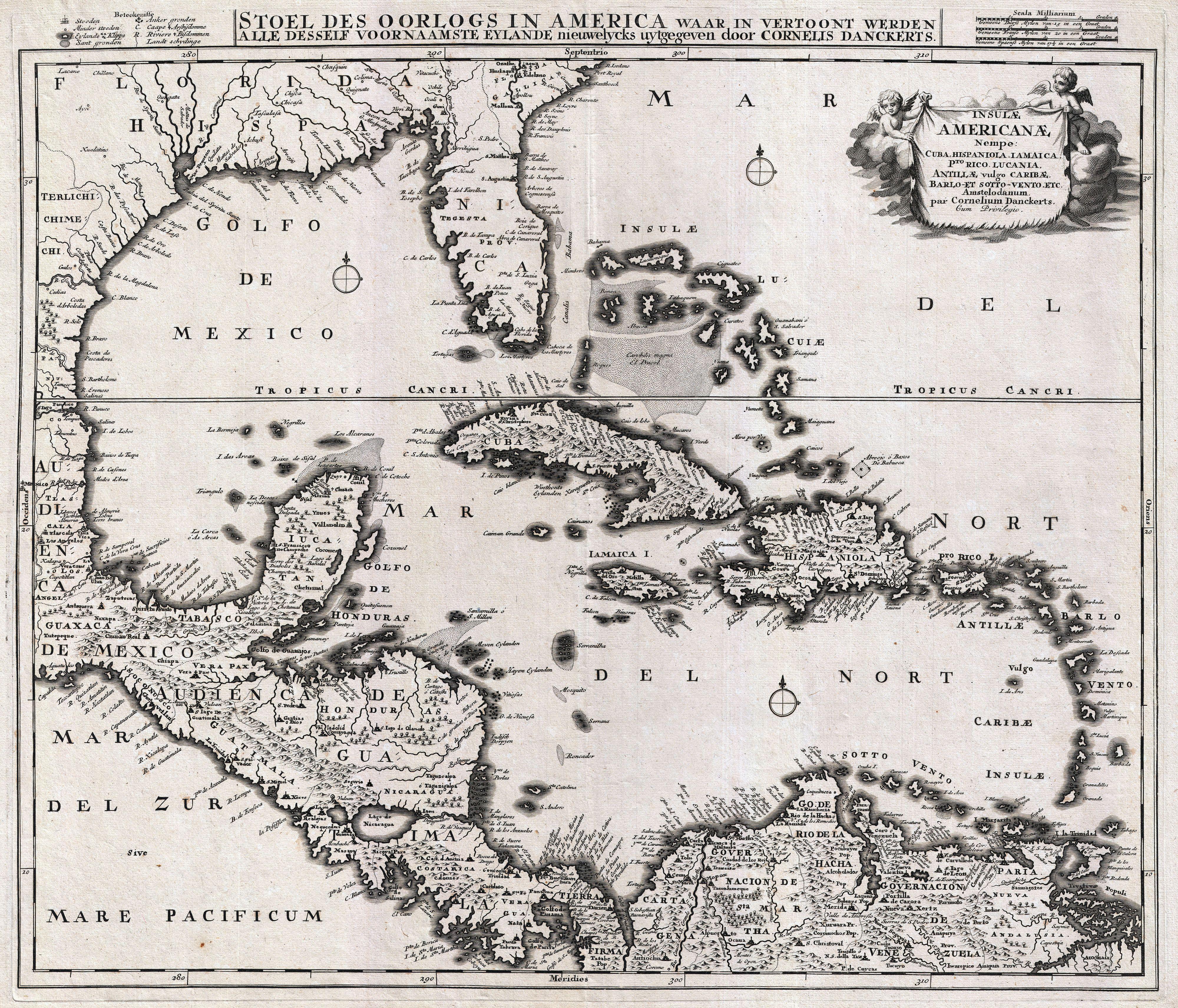
English: An absolutely stunning example of Cornelius Danckerts' important 1696 map of Florida, the West Indies, Central America, the Caribbean, and the Spanish Main. Cartographically influenced by Blaeu's 1636 map of the same region, this map covers from Mexico to the Antilles and from Florida to the Spanish Main, inclusive of Cuba, the Bahamas, Hispaniola, Jamaica, Porto Rico, and the Lesser Antilles. The detail throughout is spectacular with missions, forts, cities, ports, rivers, lakes, indigenous groups, and an assortment of additional topographical details noted. Florida is labeled as the province of Tegesta, following the convention established by Dutch cartographers Johannes de Laet and Hessel Gerritzoon in 1630. The Tegesta were an indigenous tribe active in the southeastern parts of Florida, around what is today Miami-Dade. They were encountered in the 16th century by Ponce de Leon and by one of the ships commanded by Pedro Menéndez de Avilés. Though largely subject to the more powerful tribes of western Florida, the Tegesta were among the first of Florida's indigenous groups to encounter Europeans and subsequently influenced the naming of Florida for some 200 years. Curiously, despite several expeditions and interesting earlier maps of Florida, Dankerts has chosen to leave the interior blank, noting neither the Everglades nor any of Florida's great lakes. The interesting cartographic decision to discard all previous mappings of the Florida region contrasts strikingly with the remainder of the map, which is lavishly and often speculative detailed. Following the western coast of Florida north, along the Gulf and then west towards Texas and Mexico, we can begin to see just how little was known of the Gulf Coast despite nearly 200 years of European activity in the region. The Mississippi River is entirely absent, though a great fan shaped river system does radiate northward from the Bay of Spiritu Santo (today most commonly associated with Galveston Bay). Looking northward and inland from the Gulf Coast, a number of communities appear in reference to various indigenous groups encountered by the De Soto and Coronado expeditions - these include the Chicasa, the Talacasa (whose warriors nearly overwhelmed and slaughtered De Soto's army), and Achusi. The West India Islands, centered on Cuba, are mapped with considerable accuracy though universally distorted on the north-south axis. The Bahamas are vaguely and inaccurately mapped throughout, though some attempt has been made to depict the undersea Bahama Bank. San Salvador or Guanahani, the supposed island where Columbus is said to have first landed in the New World, is noted. Central America, which sweeps diagonally across the lower left quadrant of the map is strikingly accurate with the exception of a distorted Yucatan - which here appears almost like an inversion of a similarly distorted Florida just to the northeast. Both Lake Nicaragua and the adjacent Lake Managua are noted, but are situated on an east-west rather than the correct north-south axis. Along the Spanish Main the great trading cities of Cartagena, Venezuela, and Valentia are noted, ss are a number of missions and indigenous centers in the interior. Maracaibo Bay is entirely misrepresented. Further east, Dankerts attempts to illustrate the countless islands of the Orinoco Delta. A title cartouche including two cherubs appears in the upper right quadrant. A key to the map's symbols, three distance scales, and an secondary Dutch description of the map appears above the map's printed border. The description declares that this map was made to illustrate the theater of war in the West Indies. The war in question is most likely the Nine Years' War (1688–97), fought between France and England over control of the New World. |
|||||
| Diet | 1696 (undated) | |||||
| Dimensions | height: 18.5 in (46.9 cm); width: 22 in (55.8 cm) | |||||
| Accession number |
Geographicus link: WestIndies-dankerts-1696 |
|||||
| Source/Photographer |
|
|||||
| Pomishan (Fi riyuuz dis fail) |
|
|||||
File history
Ef yuh waan see wah di file look like dem time deh, click pon dat date/time.
| Date/Time | Thumbnail | Size | User | Comment | |
|---|---|---|---|---|---|
| lates' | 16:52, 23 March 2011 | | 4,000 × 3,423 (4.2 MB) | BotMultichillT | {{subst:User:Multichill/Geographicus |link=http://www.geographicus.com/P/AntiqueMap/WestIndies-dankerts-1696 |product_name=1696 Danckerts Map of Florida, the West Indies, and the Caribbean |map_title=Insulae Americanae, Nempe: Cuba, Hispaniola, Jamaica, P |
Weh part di file use
No piej no de we lingk dis fail.
Weh part di file deh
Dis ya file use inna dem ya wiki:
- Weh part it deh pon es.wikipedia.org